
|
|
Working with Static Drillholes Creating and compositing static drillholes. |

Introduction
The imported drillhole data tables need to be further processed before they can be used for modeling, grade estimation, evaluation and data presentation.
Desurveying and Compositing Drillhole Data
Desurveying is a standard processing technique for generating 3D drillhole traces (coordinated sample intervals) from the base drillhole collars, downhole surveys and downhole samples tables. Compositing is a standard processing technique for regularizing either the length or the vertical height of desurveyed drillhole samples.
The first stage of drillhole data processing involves creating the 3D drillhole traces using the HOLES3D Command. Here the HOLES3D Process generates what are referred to as "static drillholes" (compared to "dynamic drillholes" which are generated by loading drillhole tables - please see the topic Creating Dynamic Drillholes for further details).
The second processing stage involves compositing the drillhole traces down their lengths into typically fixed length intervals, within a defined compositing "Zone" field. The range of parameter settings in COMPDH allows for the generation of composites to suit different output scenarios e.g. short fixed length composites for statistical analysis and grade estimation vs. single variable length composites per rock type interval for interpretation or string modeling purposes.
This processing generally involves using the Processes shown in the following order:
-
HOLES3D: Desurveying drillhole data tables to create 3D drillhole traces
-
COMPDH: Compositing down drillholes

Desurveying Drillhole Data Tables to Create Static Drillholes
In this example, the command HOLES3D will be used to desurvey the imported drillhole data files to create the static drillholes table dholes.dm(x). The standard Datamine drillhole data tables contain the following information:
-
dhcollar: collar coordinate, coordinate system, coordination and drilled date data.
-
dhsurvey: survey measurement depth, survey bearing and dip data.
-
dhassay: sample interval start and end depth, Au, Cu and Density assay data.
-
dhlith: sample interval start and end depth, lithology data.
-
dhzones: sample interval start and end depth, mineralized zones data.
The procedure for desurveying the drillhole data files is as follows:
-
In the Command control bar, click Find Command.
-
In the Find Command dialog, browse for and select the HOLES3D command, click Run.
-
In the HOLES3D command dialog, define the Files, Fields and Parameters settings, as shown in the table below, click OK.
Name
Property
Input Files
Collar
dhcollar
SURVEY
dhsurvey
SAMPLE1
dhlith
SAMPLE2
dhassay
SAMPLE3
dhzones
Output Files
OUT
dholes
Fields tab
BHID
BHID
XCOLLAR
XCOLLAR
YCOLLAR
YCOLLAR
ZCOLLAR
ZCOLLAR
FROM
FROM
TO
TO
AT
AT
BRG
BRG
DIP
DIP
Parameters tab
SURVSMTH
0
ENDPOINT
0
-
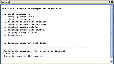
View the summary desurvey report in the Command control bar's Output pane (a successful desurveying run will show that the output file dholes contains 732 (1048) records and that all checks were successful, as shown in the diagram below:
-
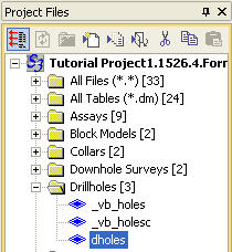
Check the Project Files control bar to make sure that the new file dholes is listed under the Drillhole folder, as shown in the diagram below:
If this file is not displayed, use the Add Existing Files button in the Project Files control bar to add this file to the project. -
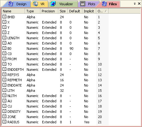
Check the new file in the Files window to make sure that the file's field Names, Size and Types are correct, as shown in the diagram below:
Compositing Static Drillholes
In this example, the Command COMPDH is going to be used to composite the static drillholes, down their lengths, into single rock type intervals defined by the rock type code field NLITH (this field is selected as the compositing "Zone" field) and by setting the INTERVAL parameter to 1000 (a distance greater than the longest continuous rock type interval as per the information in the lithology table dhlith).
The compositing procedure is as follows:
-
Select theSample Analysisribbon and thenComposite | Composite Down Drillholes
-
In the COMPDH command dialog, define the File, Field and Parameter settings as shown in the table below, click OK.
Name
Property
Input Files
IN
dholes
Output Files
OUT
dholesc
Fields tab
BHID
BHID
FROM
FROM
TO
TO
DENSITY
DENSITY
CORELOSS
Leave blank
COREREC
Leave blank
ZONE
NLITH
Parameters tab
INTERVAL
1000
MINGAP
0.05
MAXGAP
0
MINCOMP
0.001
LOSS
0
START
0
MODE
0
PRINT
0
-
View the progress of the command in the Command window, noting that the output file should contain 102 (129) records, as shown in the diagram below:
-
Check the Project Files Browser to make sure that the new file dholesc is listed under the Drillhole Files folder, as shown in the diagram below:
If this file is not displayed, use the Add Existing Files button in the Project Files control bar to add this file to the project. -
Check the new file in the Project File Explorer window, using the details in the Files window, to make sure that the file's field Names, Size and Types are correct, as shown in the diagram below:
The user defined fields ENDDATE, LITH, REFMETH and REFSYS are not in the new file - alpha fields are not transferred in the compositing process.
|
|
|